
Directions and Maps
Directions
The observatory is located at the top of the Blue Mountain Recreation area southwest of Missoula. To reach the Blue Mountain Recreation area, turn west on Blue Mountain Road off of highway 93 south of Missoula (by The PEAK Fitness Center). Head north by the entrance to the Blue Mountain Trailhead and follow the paved road around to the dirt road entrance (Forest Road 365). You’ll be turning west onto Blue Mountain Road 365 - drive up (past the frisbee golf course) for about ten and a half miles to an unsigned junction with an obvious road entering from the left. Take a sharp left (almost 180 degrees) onto this road (forest Road 2137), pass through an open gate - we will have a sign at this junction. Proceed another two miles to the fire lookout at the top of Blue Mountain. Park there and walk east about 0.3 mile on the narrow dirt road that follows the ridgeline. The Observatory Dome should be visible as you get part way down the road. Please note that the gate 2 miles below the lookout will be locked at the end of the evening, no car camping is allowed past this gate!
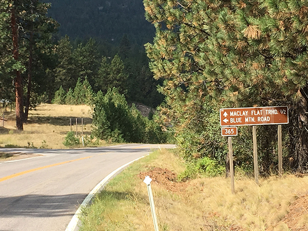
You’ll be turning west onto Blue Mountain Road 365 at this sign.
Please park at the fire lookout at the top of Blue Mountain. From the lookout, a dirt road which heads East along the summit ridge will lead you to the Observatory (about 200 yards away). Bring a flashlight for the walk back!
If you have a GPS device and would like to use a .gpx file to navigate to the observatory, download this file for use: BMO 93 to Parking.GPX
Watch this short video to see if the drive is for you - it has important information as to where to turn, rough sections of the road, and good overlooks of Missoula.
